Aerial Farm Photos Christchurch

Aerial farm photos are images culled from the use of advanced imaging and aerial photography tools. Specifically when used to photograph farm-land, this form of technology can be helpful in several ways. Firstly, aerial farm photos have been used as a form of art or to document history. It also aids you by understanding the processes that take place on a farm as well as how agriculture works and the changes that take place over time on such a landscape. Combined with GPS, aerial farm photos can help in studying and working with agriculture and crops, potential offering aid in farm management for people who work there.
The advancements and improvements are fascinating to see and people enjoy looking at the changes that have occurred with the passing of time. For farmers, it is enjoyable and pleasing to note that their hard work has made such a difference on the landscape, and these images present a completely different perspective than that which is seen from the ground. These photos are used both as a historical tool and as a form of art, but they document the changes and the beauty of the world. Aerial Farm Land Photography These advanced technologies allow for farmers to better supervise and manage their agricultural supplies. Aerial images offer tools for better diagnostics of crops, supply data for better allocation of input on the farm, and offer other tips on improved methods of farm work.
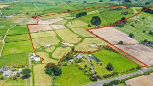
The above-ground images of a farm show the landscape, along with the boundaries and limits. More specific and advanced technology also offers information about yield of products, important landmarks, sloughs, the type of soil available, and other very applicable data. This form of technology allows for crop management as well. GPS and aerial photos allow for farmers to return to the exact same point and to view whether or not there has been an improvement in crop growth. Certain sites can be benchmarked so that farmers have specific knowledge about the performance of their products. In addition, harvesting and fertilizing, as well as other basic farming activities, can be accurately and exactly plotted and the information gained from the images can be input onto spreadsheets for the data to be examined. Aerial farm images offer many benefits for farmers and offer a beautiful view of different landscapes.